Land for Wildlife
City of Gold Coast Land for Wildlife Property Assessment Report for Cedar Creek. Awarded 'Working Towards' registration status, August 2019.
Land for Wildlife Property Assessment Report
Property Address: Cedar Creek Date of revisit: 11 June, 2019
1. Introduction
This Property Assessment Report is designed to assist you in managing your property's habitat area by outlining its ecological values, the threats to those values, and management recommendations to assist you in mitigating those threats.
Whilst incredibly rewarding, we understand habitat restoration can also be daunting. As such, we welcome you to contact a Conservation Partnerships officer as often as you need to discuss any issues you encounter, or to request a property visit.
2. Your property in the broader landscape
2.1 Connectivity
Your property adjoins Cedar Creek, a major creek that rises on the western slopes of Mount Tamborine (Scenic Rim Regional Council) drops down through a series of waterfalls and flows through the surrounding forested slopes and creek flats until it joins the Albert River. Cedar Creek also supports vegetation along its banks that is considered an important wildlife corridor, acting as a stepping stone to nearby National Parks (Tamborine National Park) and Conservation Estates (Cedar Creek Conservation Area, Wongawallan Conservation Area (Upper Cedar Creek Section)). Connections to and within large parcels of vegetation allow for wildlife movement across the landscape.
For more information on Wildlife Corridors, please refer to Note G2 in your Land for Wildlife Note Series.
2.2 Biodiversity areas
Areas in the city identified as having local environmental significance have been mapped as 'biodiversity areas'. They are fundamental elements of the city's green space network, and are conserved to maintain the diversity of terrestrial, aquatic and marine species, ecosystems and ecological processes. Your property lies within the following biodiversity area:
- Your property forms part of a Hinterland Core Habitat System. A Hinterland Core Habitat System is an extensive tract of intact habitat. It supports a variety of vegetation associations, provides habitat for diverse fauna populations and requires the highest level of protection. The Gold Coast hinterland in which your property is located, contains key elements of the World Heritage-listed Gondwana Rainforests of Australia and is home to 200 rare or threatened plant and animal species.
- Your property forms part of a Critical Corridor. Critical Corridors form the backbone of the Gold Coast and provide the linkage from the hinterland to the coast. Corridors between large tracts of vegetation allow animals to move between different areas to seek food, water, shelter and mates. Corridors also allow plants and animals to adapt to seasonal and climatic changes by providing for large scale seasonal or migratory movement from coast to inland and from low elevation to high elevation habitat. Since approximately one third of the city's native vegetation is on private land in the rural zone, private landholders play a crucial role in maintaining the vital ecological functions of critical corridors.
2.3 Catchment
Your property is situated in the Cedar Creek sub catchment of the Albert River catchment. Native vegetation on your property contributes to improved water quality, wildlife habitat and the health of the catchment in general. You can learn more about your catchment and the work its Catchment Management Group does on the City's website: www.cityofgoldcoast.com.au/catchments.
For an interactive Map Journal about the Albert River, visit: http://ggsp.maps.arcgis.com/apps/MapJournal/index.html?appid=e05ca7ca37fe4609a2ac0b3f35dce3c7#
If you want to keep track of the ecological health of your catchment you can view the annual report card on the Healthy Land and Water website: http://hlw.org.au/report-card.
3. Your property's Land for Wildlife Habitat Area
The area of your property you would like included in the Land for Wildlife scheme is referred to as your 'Habitat Area'. Your property's Habitat Area may comprise 'Retained Habitat' and/or 'Habitat under Restoration'.
The areas of 'Retained Habitat' typically display plant structure (such as height and cover) and species diversity characteristic of the vegetation type in its natural state. Areas of disturbed forest may also be considered as Retained Habitat, depending on the condition and maturity. Areas of more degraded vegetation or cleared land are considered 'Habitat under Restoration'.
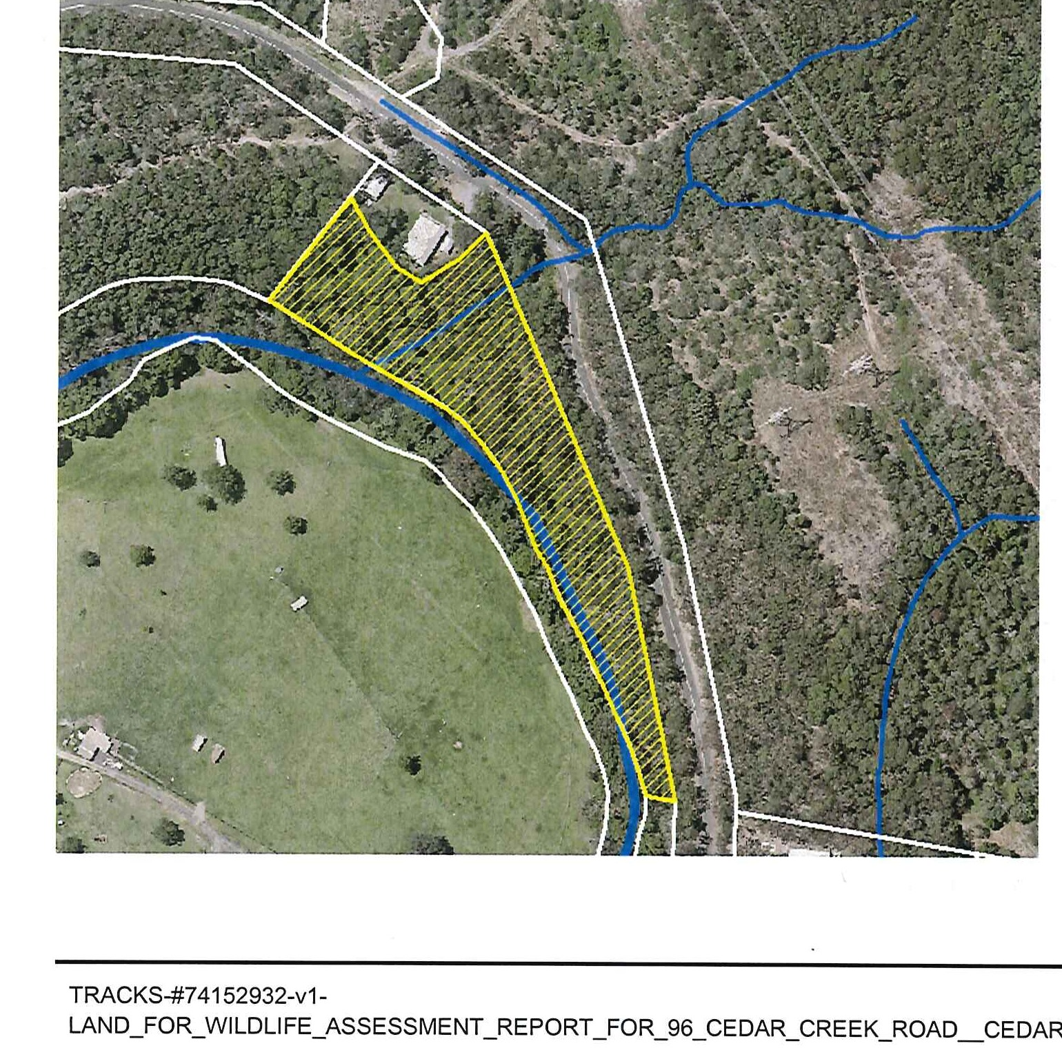
Your property's Habitat Area has been identified in the below aerial map. The area of Habitat under Restoration is highlighted in yellow and is just under a hectare in size (9,680m²).
Map 1: Your Property's Land for Wildlife Habitat Area
4. Your Habitat Area's geology and vegetation
State Regional Ecosystem mapping is used to provide a succinct description of an area's natural attributes and conservation values taking into account the landform, underlying geology and characteristic plant species. Because Regional Ecosystems include all plants, animals and other organisms, along with their non-living surroundings, they are very helpful descriptors in conservation planning and management. For a full explanation of Regional Ecosystems refer to Note V1 of the Land for Wildlife Note Series.
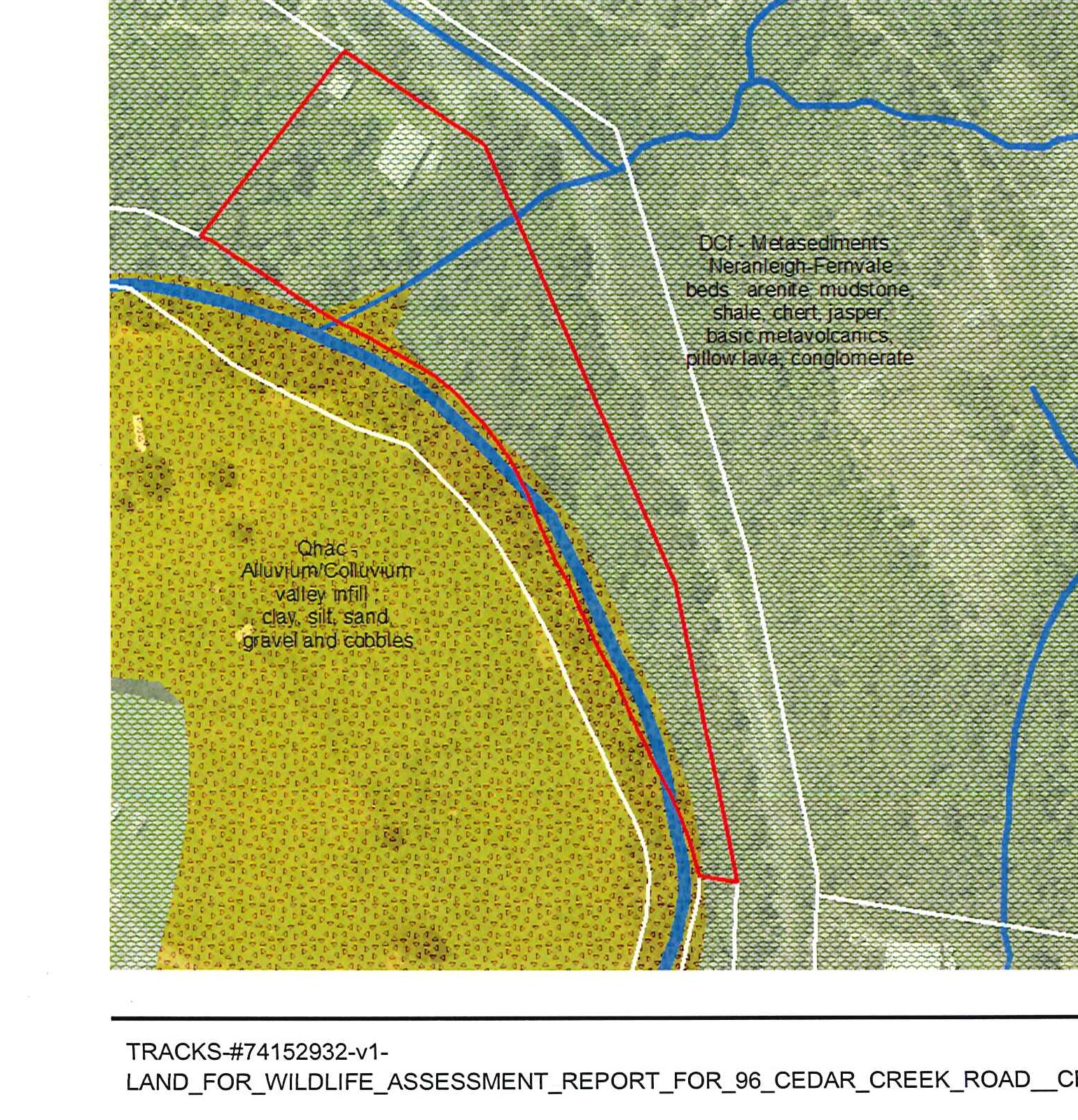
4.1 Geology
The underlying geology for your property is:
- Neranleigh-Fernvale formation. It consists of sedimentary rock formed from sediments deposited on the sea bed more than 300 million years ago, which were then altered by intense heat and pressure (metamorphosed) and uplifted to form the backbone of the Gold Coast hinterland — our most common type of rock. It typically supports eucalypt forest or, less commonly, rainforest in moist gullies or on protected south-facing slopes.
- Alluvium/colluvium valley infill characterises the hinterland valleys in the central and northern Gold Coast between Nerang and Beenleigh. Alluvial soils are fertile and can support a greater density and diversity of plants which in turn provides important fauna habitat and corridors. They consist of clay, silt, sands, gravel and cobbles.
Map 2: Your Property's geology
4.2 Vegetation Types
In the City of Gold Coast the plant species of each Regional Ecosystem (RE) have been listed and described in more detail as Vegetation Types (VT). Vegetation mapping allows us to see where the different Vegetation Types occur across the landscape. In areas of disturbed vegetation, the Vegetation Type is preceded with a 'd_1' and in areas of regrowth vegetation, an 'r_1'. The below aerial map shows that three Vegetation Types are mapped on your property. Due to the scale at which vegetation mapping has been undertaken, vegetation may differ on ground, especially in gullies and poorly drained situations.
Map 3: Your Property's Vegetation Types
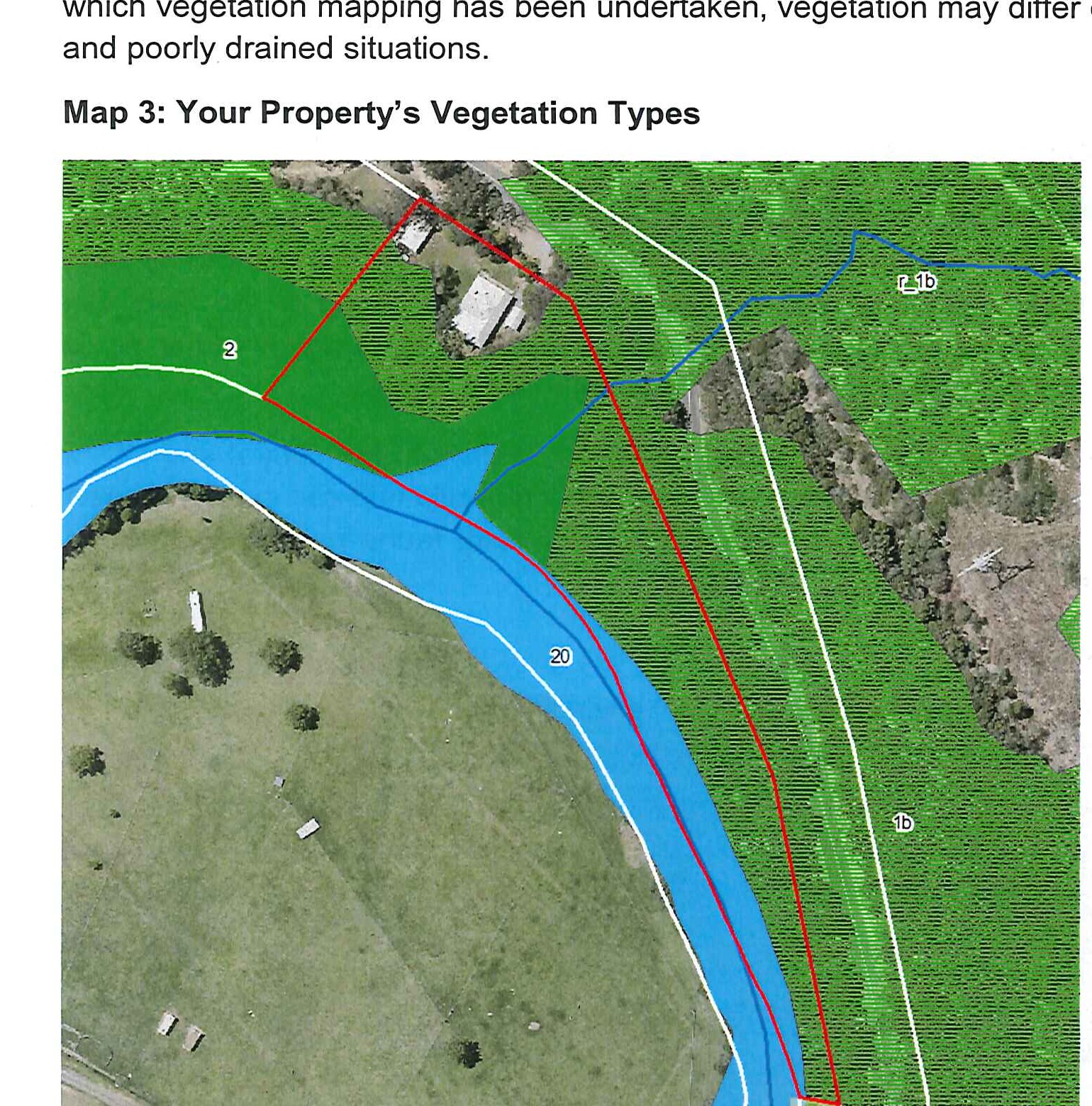
Table 1: Summary of Habitat Area's vegetation
| VT | RE | Short Description | Conservation Status (Vegetation Management Act 1999) | Approx. area (m²) covering property |
|---|---|---|---|---|
| 2 | 12.11.3a | Brush Box – open forest often with rainforest understorey on metasediments. | Least concern | 2440m² |
| 20 | 12.3.7 | Forest Red Gum, River Oak – woodland on alluvium. | Least concern | 1820m² |
| 1b | 12.11.3 | Small fruited Grey Gum, Grey Ironbark – open forest to woodland on metasediments. | Least concern | 5420m² |
Please refer to the fact sheets provided during your property visit for more detailed descriptions of the Vegetation Types mapped in your habitat area.
4.2.1 Vegetation status
Under the Vegetation Management Act 1999, a Regional Ecosystem is listed as:
- 'Endangered' if remnant vegetation is less than 10 per cent of its pre-clearing extent across the bioregion; or 10-30% of its pre-clearing extent remains and the remnant vegetation is less than 10,000 hectares.
- 'Of concern' if remnant vegetation is 10-30 per cent of its pre-clearing extent across the bioregion; or more than 30 per cent of its pre-clearing extent remains and the remnant extent is less than 10,000 hectares.
- 'Least concern' if remnant vegetation is over 30 per cent of its pre-clearing extent across the bioregion, and the remnant area is greater than 10,000 hectares.
Refer to Note V1 for more information regarding Regional Ecosystems.
5. Your Habitat Area's ecological values
5.1 Habitat under Restoration
Whilst historically degraded and cleared in the past, the ecological value of Habitat under Restoration areas should continue to improve as the vegetation matures and the weeds are reduced. The Habitat under Restoration area:
- contains good diversity of large native canopy species along Cedar Creek including large stands of River Oak (Casuarina cunningamiana), Native Elm (Aphananthe philippinensis), Sandpaper Fig (Ficus coronata), Silky Oak (Grevillea robusta). There is also a good diversity of understorey species along Cedar Creek, including River Mat-rush (Lomandra hystrix). As weeds are reduced around these canopy species, the vegetation surrounding them will continue to improve and you will start seeing more regeneration of native species.
- shows evidence of natural regeneration e.g. young plants naturally coming up. Whilst small now, these saplings will be the large trees of the future, with the potential to develop hollows and provide further habitat.
- provides habitat suitable for threatened fauna e.g. Koalas (Note A4) with reported Koala sightings east of your property. For more information regarding this species and to report sightings on your property, head to www.goldcoast.qld.gov.au/koala or http://www.goldcoastflorafauna.com.au/default.aspx.
5.2 Riparian areas
5.2.1 Rivers, creeks and gullies
Cedar Creek adjoins your property and you have an ephemeral creek that flows intermittently. Riparian vegetation along rivers, creeks and gullies is very important. It stabilises banks, reduces erosion, improves water quality and provides important wildlife habitat. By ensuring you have a good buffer of riparian vegetation along your property's waterways, you will also increase their resilience to flood events (refer to Note W1 for more information on riparian management and restoration). You have begun carrying out restoration works in your gully which could benefit from ongoing restoration work based on the South East Queensland Ecological Restoration Framework given to you during the site visit. Ideally healthy creeks show the following characteristics:
- healthy, native stream bank vegetation (including a good diversity of trees, shrubs and sedges), forming a wide corridor along most of the stream.
- overhanging or fringing vegetation, which helps shade the water and keeps it cooler. This maintains higher levels of dissolved oxygen, which is important for aquatic life, and discourages weeds and algal growth.
- clear water with little or no evidence of bank erosion, slumping or sedimentation.
- the presence of birds and predatory insects, like dragonflies, indicating good fauna habitat.
- the presence of in-stream habitat, e.g. logs (referred to as snags) and rocks. As well as cooling the water, overhanging vegetation also provides food for in-stream fauna.
6. Threats to your Area's ecological values
6.1 Weeds
Weeds pose the greatest threat to the property's values. Some weeds have the potential to displace native vegetation and in severe cases disrupt ecosystem function and destroy habitat.
Table 2: Weeds noted onsite
| Common name | Species name | Form |
|---|---|---|
| Balloon Vine | Cardiospermum grandiflorum | Vine |
| Black Eyed Susan | Thunbergia alata | Vine |
| Blue Billygoat Weed | Ageratum houstonianum | Ground cover |
| Brazilian Nightshade | Solanum seaforthianum | Vine |
| Camphor Laurel | Cinnamomum camphora | Tree |
| Cocos Palm | Syagrus romanzoffiana | Tree |
| Creeping Inch Plant | Callisia repens | Ground cover |
| Creeping Lantana | Lantana montevidensis | Ground cover |
| Fishbone Fern | Nephrolepis cordifolia | Ground cover |
| False agave | Furcraea foetida and Furcraea selloa | Shrub |
| Giant Devils Fig | Solanum chrysotrichum syn. S. hispidum | Shrub |
| Lantana | Lantana camara | Shrub |
| Mistflower | Ageratina riparia | Ground cover |
| Molasses Grass | Melinis minutiflora | Grass |
| Ochna | Ochna serrulata | Shrub |
| Purple Succulent | Callisia fragrans | Ground cover |
| Silverleaf Desmodium | Desmodium uncinatum | Vine |
| Small-Leaf Privet | Ligustrum sinense | Shrub |
| White Passionflower | Passiflora subpeltata | Vine |
As weed control progresses, secondary weeds may appear. Refer to the 'Environmental Weeds and Native Alternatives' booklet for images of other weeds at http://www.goldcoast.qld.gov.au/documents/bf/environmental_weeds_web.pdf, as well as information on their control. Council's website also has six helpful videos to guide weed management with best-practice tips and techniques at http://www.goldcoast.qld.gov.au/environment/ecological-restoration-techniques-46281.html.
The Department of Agriculture and Fisheries at www.daf.qld.gov.au also have fact sheets, research papers and an identification tool on their website that can be referred to.
6.2 Feral animals
Pest animals commonly found in bushland, which harm native wildlife or habitat include:
- wild dogs and feral cats (including free ranging domestic dogs and cats)
- foxes
- Common mynas
- deer.
Fauna monitoring cameras are available to Land for Wildlife members interested in determining what native and pest wildlife is on their property. Talk to your Conservation Partnerships Officer if you would like to borrow one. If pest species are present, you can consider control strategies such as:
- making the habitat less desirable e.g. eliminate food sources like left over pet food, uncovered compost, fallen fruit in orchards, Cocos Palms (which attract mynas and deer).
- trapping the animal (owners are responsible for hiring or purchasing traps and their subsequent use).
Head to the City's website www.goldcoast.qld.gov.au/pestsandweeds or phone 1300 GOLDCOAST (1300 465 326) to report a pest or for more information regarding these species and their management.
6.3 Erosion
Vegetation on stream banks helps support soil so the bank does not erode and collapse. A combination of deep rooted trees on the upper banks and the fine root systems of sedges lining the creek is generally the most effective safeguard against stream bank collapse. Comprehensive information on creek and gully erosion can be found at https://www.catchmentsandcreeks.com.au/M-fact_sheets-ESC.html.
6.4 Fire
Properties can be affected by planned and unplanned fire (wildfire). Fire becomes a threat to native ecosystems if:
- it extends into vegetation types which should not be burnt e.g. rainforest and creek areas
- the frequency and/or intensity of the fire is too high
- the area burnt is too large.
Fire management guidelines are provided on the Department of Environment and Heritage Protection (EHP) website for each Regional Ecosystem: www.ehp.qld.gov.au/ecosystems/biodiversity/regional-ecosystems/fire-management. Generally speaking:
- Eucalypt forest is adapted to an occasional fire. Generally, a shorter fire interval (e.g. 4–5 years) would maintain an open grassy understorey while a longer interval (e.g. 10–20 years) would permit a thicker shrubby understorey.
To minimise fauna impacts when preparing to burn or in anticipation of a wildfire, you can:
- restrict the fire to ecosystems which are tolerant of fire and avoid burning near watercourses
- protect old habitat trees and hollow logs by raking combustible bark and leaves away from their base
- retain unburnt patches to act as refuges for fauna and plants and to assist re-colonisation of burnt areas
- assess if there are particular species of plants or animals on your property which need a very specific fire regime and plan accordingly (Land for Wildlife officers can advise — a more thorough flora/fauna survey may be needed)
- remove weedy understorey species like Lantana and Molasses Grass which could present a fire hazard in dry conditions — this should help prevent wildfire spreading and reduce the intensity of the burn.
Generally, a mosaic burn pattern (i.e. burning in patches) is considered ideal as it provides a varied habitat (burnt and unburnt) for fauna. Unplanned burns (wildfires) sometimes make planned burning unnecessary. It is very useful to keep a record of fires on the property (date of fire, intensity, and area affected, to aid in fire management planning).
If you wish to burn for ecological purposes, Land for Wildlife officers can assist you in assessing your property to see if an ecological burn could benefit wildlife. However, the decision to burn and legal responsibility remains with the landholder. This is why the rural fire service and your neighbours must be consulted and a permit obtained from your Fire Warden. No permit — no fire!
Fire ecology is a complex subject. For detailed information about fire ecology and a guide on preparing a Bushfire Management Plan which takes wildlife into consideration refer to the SEQ Fire & Biodiversity Website: www.fireandbiodiversity.org.au/publications.html. Additional information can also be found within Notes F1, F2, F3 and F4 of your Land for Wildlife Queensland Note Series.
Concerning matters of protection of life and property, advice should be sought from your local fire warden or rural fire brigade officers.
7. Restoration recommendations
We highly recommend you take advantage of the free restoration workshop offered to Land for Wildlife members. The workshop entitles attendees to a restoration toolkit, herbicides and free plants. Workshops are based on the Southeast Queensland Ecological Restoration Framework, which is available through Land for Wildlife.
The purpose of ecological restoration is to restore the structure, function and integrity of an ecosystem that has been degraded, damaged or destroyed. In its natural state, the ecosystem will have the right species and structure (groundcover, understorey and canopy), plants of various growth stages and ages, and good resilience. Resilience is the ecosystem's ability to recover from disturbance through natural regeneration with seed found in the seed bank or canopy, or brought in via wind, water, animals or gravity. The aim is to establish native forest cover which is self-maintaining and needs little effort to manage.
There are four approaches to ecological restoration, which are explained on page 34 of the SEQ Ecological Restoration Framework: Natural Regeneration, Assisted Natural Regeneration, Reconstruction and Fabrication. Depending on your site, one or more approach may be appropriate. A flowchart on page 37 of the Framework is designed to assist you in determining which method is best. For your site, we recommend assisted natural regeneration, which involves weed control.
Weed control should always be planned in the context of habitat restoration — killing weeds without restoring habitat will usually just result in more weeds. Therefore, it is vital to work in manageable sized zones that you will be able to maintain as natives re-establish. Work systematically (to minimise the likelihood of missing weeds) and comprehensively to control all weeds in the zone. Do not target one or two species of weed only. Doing so, will only free up space for other weeds to move into and you will essentially be replacing one weed with another.
After initially treating the weeds, return to the zone regularly to retreat or hand-pull any new growth or missed plants. As time goes by and the weeds' seed bank in the soil reduces, you will see a shift in the dominant species from weeds to natives.
When prioritising areas or weeds to tackle, consider the ecological value of the area, the invasiveness of the weed and the time of year the weed will go to seed. By controlling weeds prior to their flowering/seeding period you will avoid increasing the seed bank and therefore reduce the follow-up maintenance required in the area. Weeds provide habitat so need to be removed in stages to avoid displacing fauna living in them. Consider what fauna is using the weed as habitat at certain times of year.
Generally speaking, work from areas of small weed infestation to those of larger infestations. This prevents small weed infestations taking over relatively intact areas of bushland while you focus your efforts on an area with less ecological value. By securing intact areas, you are securing a source of seeds etc., which will aid natural regeneration in the more degraded areas. However, this rule may not apply when a more degraded area is identified as a higher priority.
To avoid weed seed entering areas you've already treated, try to work in a manner that reduces the likelihood of weed seed being reintroduced. For example, work from the top of the slopes down and when in a waterway, start upstream and work down the catchment. This will reduce weed seed entering the site through rain runoff, gravity roll and stream flow.
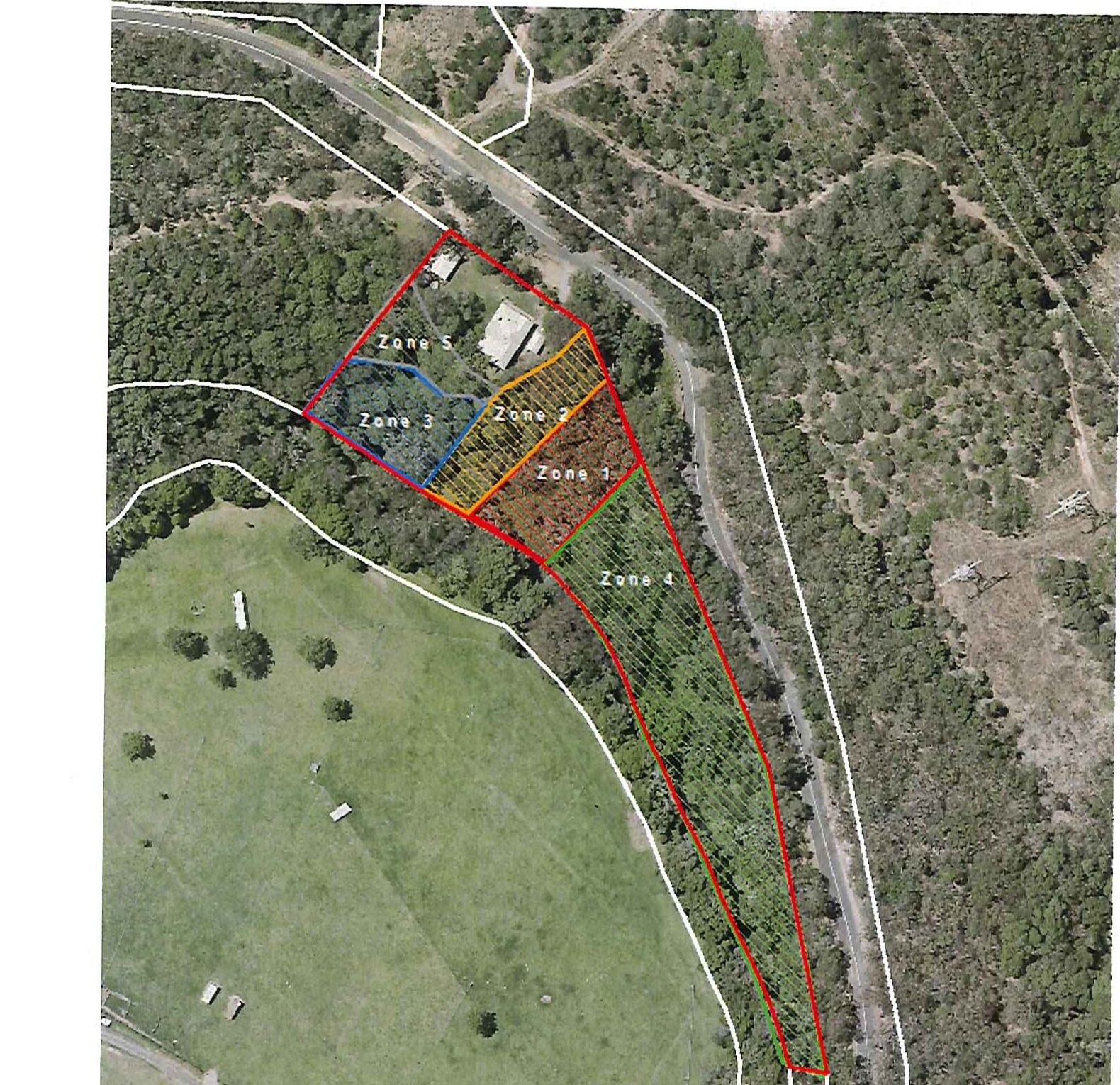
7.1 Management zones for your Habitat Area
For the purpose of ecological restoration, it is helpful to divide your property's vegetation into management zones based on the type and intensity of management required and logistical considerations e.g. ease of access. Management zones can assist with prioritising work (based on the invasiveness of weeds present and their flowering/seeding periods as well as the ecological value of the zone e.g. endangered plants/ecosystem) and maintaining focus and follow-up control, to ensure weed control efforts are not wasted. Management zones on your property are based on the lantana control that you have carried out to date, and are recommended to be:
- Zone 1 — Highlighted in red. This is a gully containing remnant rainforest trees. This area was historically cleared and is dominated by Lantana. In recent months a large amount of primary weed control has been undertaken by the landholder.
- Zone 2 — Highlighted in orange. The main weeds in this area are juvenile Camphor laurel trees, Ochna, Cocos palms and low level white passionflower and creeping lantana (amongst other weeds) in the understorey.
- Zone 3 — Highlighted in blue. This area contains some remnant/regrowth rainforest trees interspersed dense thickets of Lantana and a number of weed vines including Black-eyed Susan and Balloon Vine.
- Zone 4 — Highlighted in green. This area is predominantly open eucalypt vegetation in the north-eastern boundary.
- Zone 5 — Highlighted in grey. This embankment is covered in dense bunds of Lantana.
Map 4: Suggested management zones
7.2 Weed control in your Habitat Area
Below are weed management suggestions for the control of weeds identified in the Habitat Area. These areas are intended to be used as a guide only to assist you in the process. The Weed Control Methods recommended in the following paragraphs are discussed in Note EW2 as well as the City of Gold Coast's 'Environmental Weeds and Native Alternative' booklet and the appendix at the end of this document. Please refer to Appendix C in your copy of the Southeast Queensland Ecological Restoration Framework for detailed information including herbicide mixing rates. Please also refer to Council's restoration videos http://www.goldcoast.qld.gov.au/environment/ecological-restoration-techniques-46281.html. Please feel welcome to contact your Conservation Partnerships Officer if you require more advice about weed identification or weed control.
7.2.1 Recommendations
Carrying out regular weed control work — even 2 hours a month can lead to dramatic changes over time. Use shaded areas and early mornings when weather is hot. Take advantage of your existing track to help make work easier, safer and more enjoyable.
The gradual reduction and control of priority weed species will allow for natural regeneration to replace exotics over time. It is generally best to work from areas least infested to areas most infested. As with all weed control efforts, ongoing regular maintenance is paramount to successful control.
Weed management should occur consecutively from Zone 1 to Zone 5, to ensure weed control is undertaken in a systematic and consolidated approach. Areas should stabilise and be at maintenance level prior to moving to the next area.
Consider how high seasonal flows may impact your creek banks when controlling weeds along the gully and Cedar Creek, and adjust your weed control methods accordingly. Control techniques such as cut, scrape & paint and spot spraying leave the root systems intact (so they can continue to stabilise the bank) and are therefore preferable to hand pulling. Retaining vegetation (possibly including some weeds) to secure creek banks during the wet season reduces the likelihood of soil erosion and sedimentation.
Zone Recommendations
Zones should be worked consecutively from Zone 1 to Zone 5, to ensure weed control is undertaken in a systematic and consolidated approach. Areas should stabilise and be at maintenance level prior to moving to the next area.
Suggested actions below are in order of the priority in which they should be undertaken on ground, starting with primary (first) works to follow-up (secondary work and ongoing maintenance).
Priorities
- Prioritise the control of Creeping inch plant and Silverleaf Desmodium that are growing in your lawn near the house. They are currently only small amounts that are present on your property. However, they are beginning to encroach into your habitat area (Zone 2). Silverleaf Desmodium can be spot sprayed using a combination Glyphosate (Gly) + Metsulfuron Methyl (MM) at a rate of 100ml Gly + 1.5g MM in 10L water + Spray Adjuvant (A) + Colour marking Dye (D). Creeping inch plant can treated with 200mL Gly + 1.5g MM in 10L water + A + D.
- Prioritise control of Giant devils fig and Wild tobacco as currently only small amounts are present on the property. Use the cut, scrape and paint method for saplings or Inject mature plants at a rate of 1:1.5 (one part Gly to one and a half parts water). Spot spray seedlings using a combination of Gly and MM at a rate of 1:50 + 1.5g/10L and surfactant.
- Ensure ongoing follow-up control is undertaken for secondary germination of Giant devils fig.
- Monitor and manage the spread of Creeping inch plant and Silverleaf Desmodium.
- Monitor and manage the spread of other garden ornamentals surrounding the house (purple succulent and False agave). Ensure garden cuttings are not disposed into bushland areas as many have the ability to spread vegetatively (i.e. from cuttings).
Zone 1–4
- In recent months a large amount of primary weed control has been undertaken by the landholder in Zone 1. When treating woody weeds in the gully and along Cedar Creek, ensure best practice is being implemented by using the cut-scrape-paint technique to leave the root systems intact (so they can continue to stabilise the bank) and are therefore preferable to hand pulling. Retaining vegetation (possibly including some weeds) to secure creek banks during the wet season reduces the likelihood of soil erosion and soil loss.
- Whilst Zone 1 is exhibiting some natural regeneration following the treatment of Lantana, significant follow-up weed control regime will be required for several years to prevent weed regrowth from smothering native plants until native trees can close the canopy and capture the site. Planting of Lomandra in the gully where Lantana has been physically removed may be required to help prevent erosion.
- Initial work will involve the primary handwork (cut, scrape and paint and hand-pull) of other woody weeds and vines. Woody weeds other than Lantana that have not been treated include Ochna, Small-Leaf Privet and Camphor Laurel. Weed debris should be spread and left on site to act as mulch (rather than removing or piling). Paint treated stems with Glyphosate at 1:1.5 (one part Glyphosate to one and a half parts water). Throughout this process, hand-weed sporadic herbaceous weeds such as Crofton, Mistflower and Blue billygoat weed.
- Exotic vines (i.e. White passionflower, Black Eyed Susan, Balloon Vine) that are climbing into the canopy can be cut above head height, then cut, scraped and painted at ground level. The debris within the tree will die off over time. Vines running along the ground can either be cut, scraped and painted, hand pulled or spot sprayed depending on their size.
- After the initial weed debris has begun to wilt and brown (usually a couple of weeks) remaining exotic herbaceous weeds and grasses can be treated.
- Larger infestations of Mistflower, Crofton and Blue billygoat can be spot sprayed with Glyphosate at 1:100. In areas with native grasses (or grasses you want to retain) use a Metsulfuron Methyl herbicide, which is broad leaved selective and won't affect grasses.
- Molasses grass can be hand pulled, crowned or spot sprayed for larger infestations using Glyphosate at 1:100 (one part Gly to 100 parts water). Maintain exotic grasses along the edge of the road for soil and road stabilisation.
- Spot spray Fishbone fern in areas with native grasses with Metsulfuron Methyl at 1g MM: 10L and surfactant.
- Cocos palm seedlings can be spot sprayed using a combination of Glyphosate and Metsulfuron Methyl at 1:50 and 1.5g/10L water and surfactant. Trees can be drilled and injected with Glyphosate at 1:1.5.
- Retain and increase native groundcovers including Basket grass, Native violet and Blue commelina as these groundcovers suppress weed development and reduce follow-up maintenance requirements over time.
- Promote native saplings and seedlings identified within the zones including Wattle, Macaranga, Foambark, and Cheese tree.
- Stem inject large Camphor laurels after understorey weed control has been completed as light, water and nutrients can then be utilised by the remaining native plants.
- Monitor and manage secondary weed germination (this will increase significantly within wet areas near the creek). This will include cut, scraping and painting and/or hand pulling emerging saplings (i.e. a mass germination of Giant devils fig & Wild tobacco is likely to occur after initial primary weed control).
Zone 5
- Zone 5 is largely Lantana and should be left untreated until all other zones are at maintenance levels.
When using herbicides for weed control, always follow label instructions and wear suitably protective clothing. Appendix 1 — Weed control methods are detailed below.
Once you have read this Assessment Report, you might be ready to begin weed control, please contact Melanie Mott on (07) 5582 8915 to arrange another site visit where she can demonstrate some of the techniques detailed in this report. Attending the next Ecological Restoration workshop is also highly recommended. This workshop will teach you how to plan your site's restoration, implement a variety of weed control techniques, build your native vegetation's resilience and increase wildlife habitat.
And finally… protecting and restoring your property's wildlife habitat has great rewards. Always take time to enjoy your native bushland and the wildlife it supports!
Appendix 1 — Weed control methods
Cut, scrape and paint. This is a common method used to treat woody weeds and some vines. When cutting the plant's stem, cut as close to its base as possible (1–2 cm above ground level), to decrease the distance the herbicide needs to travel to the plant's roots. Apply the appropriate herbicide within 10 seconds to the cut surface, before the plant seals the wound. Below the cut mark along the sides of the stump, and along any exposed roots, scrape the outer layer gently with a knife until you reach green tissue and again, apply herbicide within 10 seconds. Some herbicides, such as those containing Glyphosate, are non-residual. That is, they break down on contact with soil. Therefore, surfaces that have been cut or scraped need to be clean of soil prior to herbicide application. Break remaining branches down and leave as mulch to decompose.
Stem Injection (i.e. 'Frill and Fill' or 'Drill and Fill'). These methods involve either cutting into the tree using a tomahawk or similar, or drilling into it, both on a 45 degree angle (approximately every 10 cm around the base of each stump/fork). Fill the cuts/holes with the appropriate herbicide immediately. Exposed roots and the insides of forks can also be cut or drilled into and filled with herbicide. When making cuts or drilling holes, try to do so reasonably close to the tree's base to reduce the distance the herbicide needs to travel to the roots. Further, avoid cutting/drilling into the centre of the tree's stump as this is the tree's heartwood, which is dead material. Instead, aim for the sapwood which lies beneath the bark and is where the cells that move material throughout the tree are located. When Frill and Filling, do not ringbark the tree. Instead, to inject further herbicide, do two or three rows of cuts in a brick pattern.
Scrape and Paint. This method is commonly used to treat many species of vines. Scrape one side of the stem for approximately 100cm, leave a 5 cm space, then scrape the other side of the stem for approximately 100cm. Apply the appropriate herbicide to the scrapes immediately. Try to scrape as much of the stem as possible.
Split and Paint is used to increase success on difficult to treat woody weeds with thin bark and long or kinked tapped roots, such as Ochna. After using the Cut, Scrape and Paint method, split the stump using a knife or tomahawk and liberally apply herbicide down into the split. Alternatively, drill into the stump and apply herbicide.
Spot Spray. Spraying has a broad range of applications in treating all weed species, particularly for seedlings, groundcovers and grasses. Spraying applies a herbicide solution to the surface of the leaves. The use of a surfactant can improve the uptake of the herbicide by the plant by increasing the herbicide's surface area and is particularly useful when spraying plants with waxy leaves. The use of a dye can also assist with tracking which areas have been treated.
Crowning is a very effective and efficient method of removing weeds with rhizomes etc. such as Basket and Climbing Asparagus. Grasp the leaves or stems together so the base of the plant is clearly visible. Insert a moderately sharp knife on an angle close to the 'crown' and cut through all the roots around the crown. Leave the roots in the ground, as these are not the reproductive mechanism and will decompose in situ. Remove the 'crown' and dispose of appropriately.
Herbicides
Amongst other things, the success of herbicide treatment is dependent on the mixing rate. Mixing rates vary depending on the control method, herbicide etc. employed. Refer to the relevant weed fact sheets for the appropriate mixing rate and when using herbicides, always follow label instructions and wear suitably protective clothing.